Office of Public Works
Flood Risk Management Plan
North Western - 2018
Published : 25th Nov 2024
The Office of Public Works North Western Flood Risk Management Plan Report, published in 2018, highlights the risk of flooding in Clonmany Village of residential properties, business properties, a Community Centre and the Clonmany Waste Water Treatment Works.

FRMP_Final2018_RiverBasin_01.pdf


‘A small number of residential properties and a couple of business properties are affected by flooding during a 1% AEP event in Clonmany. A Community Centre which is classified as a highly vulnerable property is at risk along with Clonmany Waste Water Treatment Works.’
The above OPW statement jumps off the page and provides undeniable proof that State Bodies were aware of the flooding risks in Clonmany.
Donegal County Council Planning Department granted planning approval to Clonmany Enterprise Development Limited's planning application for the Parochial Field on 22/08/2024. A planning submission/objection highlighted the following potential amplified flooding concern due to building of a riverside embankment at the bottom of the Parochial Field. This riverside embankment was built after the exceptional August 2017 Flood.
- Potential Amplified Flooding of multiple Elderly Residents
- Potential Amplified Flooding of Riverside Park Estate (50+ Defective Blocks Homes)
- Potential Amplified Flooding upstream of Shamrock Park (Clonmany Shamrock FC) and the adjacent Clonmany Community Centre
- Potential Amplified Flooding upstream of Clonmany Wastewater Treatment Plant
There is no reference to this 2018 Office of Public Works North Western Flood Risk Management Plan Report in the Donegal County Council’s ‘Planner’s Report and Recommendation’ document.

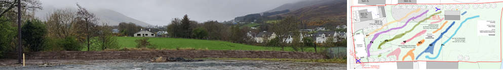
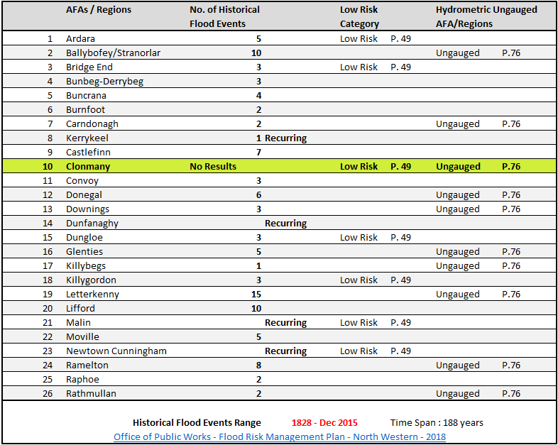
Page 23 and 24 of this Flood Risk Management Report contains 'Table 2.2 : Summary of Historical Flood Events for each AFA'. The tabulated data contains timeline historical flood data indicators for 26 regions throughout Donegal, from Killybegs up to Malin, Bunbeg - Derrybeg across to Lifford. The timeline for the historical indicators ranges from 1828 - Dec 2015.
( AFA - Areas for Further Assessment )
Clonmany is the only region of the 26 regions that has no historical flood data indicators. It has been attributed the tag 'No results'.
Generally, historical evidence has provided an indication that this location is susceptible to flooding following heavy rainfall and subsequent overland flow. Overall there is moderate confidence in both the hydrology and hydraulics of the Clonmany AFA as no hydrometric gauges are located within the model extents to support calibration.
Due to the small number of receptors affected within Clonmany it has been agreed as a low/no risk AFA and therefore the existing maintenance regime should continue in order to maintain the current SoP.
OPW - North Western - Flood Risk Management Plan Report - Page 13
In the North Western River Basin, the level of risk has been determined as being low in the following AFAs:
- Clonmany
OPW - North Western - Flood Risk Management Plan Report - Page 49
OPW - North Western - Flood Risk Management Plan Report - Page 64
AFAs which are presently ungauged but are considered to have significant flood risk, and
as such would significantly benefit from the installation of new gauge stations are identified
as follows:
- Clonmany (Ballynahallan River)
OPW - North Western - Flood Risk Management Plan Report - Page 76
This website contains a Clonmany Historical Flooding section and a Flooding Feedback section which aims to provide the Office of Public Works with relevant Historical Flooding Information for the Clonmany region.
This Flood Risk Management Plan Report has assessed Clonmany as a low/no risk AFA ( Page 13 ). What are the criteria behind this assessment? The report lists no historical flooding history for the region ( Page 23 & 24 ) and informs us that there are no hydrometric gauges in the area. Yet, we are informed that the Ballynahallan River is a significant flood risk and that this river would benefit from the installation of new hydrometric gauging stations ( Page 76 ).
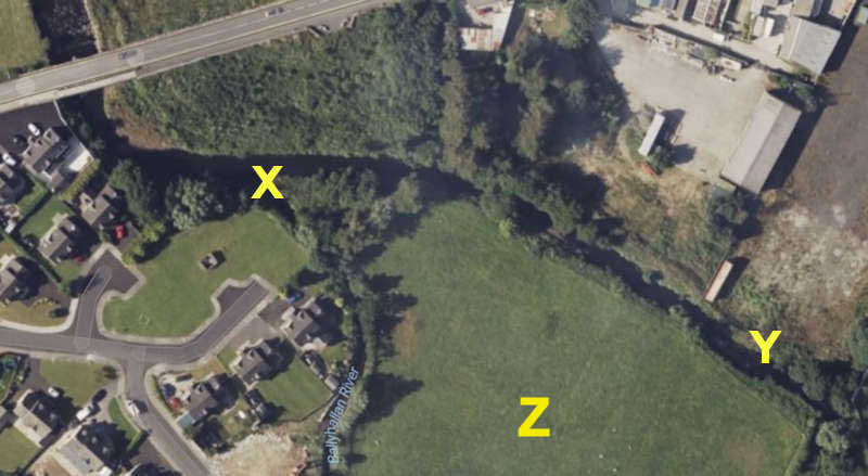
Y - Parochial Field Riverside Embankment
Z - Abandoned Clonmany Shamrocks FC Football Pitch Planning Application
For the benefit of people reading this, the Ballynahallan River runs beside the Riverside Park Estate (50+ Defective Blocks Homes) and joins the Clonmany River, 60 metres before the Big Bridge at the bottom of the village. This Big Bridge occasionally become a bottleneck for floods, as in the devastating 2017 flood which flooded out elderly residents at the bottom of the village, Riverside Park Estate, Shamrock Park including running track, Clonmany Community Centre and the Clonmany Wastewater Treatment Plant. The Clonmany Wastewater Treatment Plant contaminated the floodwaters and resulted in the Community Centre being contaminated with 'black scum' as witnessed and described by the former manager of the Community Centre in the Inishowen Rivers Trust 'Night of the Big Flood' YouTube video.
It is essential the Office of Public Works correctly assesses the Flood Risk to the Clonmany area. Flood risk assessments are crucial for a variety of reasons, including:
- Protecting lives and property: By understanding the potential risks, communities can implement measures to protect people and infrastructure from the devastating impacts of floods. This can include early warning systems, evacuation plans, and flood-resistant construction.
- Informing planning and development: Flood risk assessments help ensure that new developments are built in safe locations and are designed to withstand potential flooding. This helps prevent future flood damage and reduces the financial burden on communities.
- Managing natural resources: By understanding the impact of floods on water resources and ecosystems, communities can develop strategies to protect these valuable assets. Promoting economic resilience: Floods can have significant economic impacts on communities. By mitigating flood risks, communities can protect businesses, infrastructure, and jobs, ensuring long-term economic stability.
- Improving community preparedness: Flood risk assessments can help communities prepare for and respond to floods more effectively, reducing the impact of these events on people's lives.
Overall, flood risk assessments play a critical role in protecting communities, promoting sustainable development, and ensuring the well-being of people and the environment.
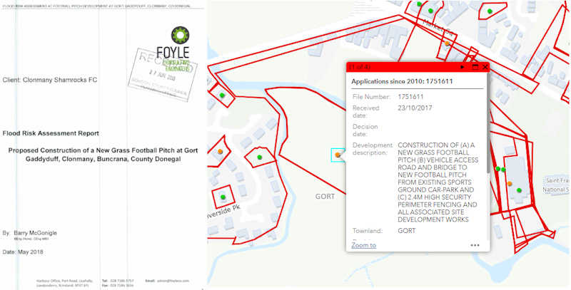
The following is an example of such. The '3.4 Previous Flooding of the Site' section included in a planning application by Clonmany Shamrocks FC for the development of a new grass football pitch. This proposed development was just across the Clonmany River from the Parochial Field and it adjoins the Ballyhallan (Ballynahallan) River. The application's 'Flood Risk Assessment Report' was prepared by Foyle Consulting Engineering using OPW information.
'Flood Risk Assessment Report' - Foyle Consulting Engineering
Clonmany Shamrocks FC did not continue with the proposed development in light of the 2107 floods.
DSFRA-ROD-EWE-SW_AE-RP-EN-40001
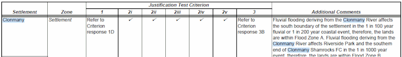
The Donegal County Council County Development Plan, Final Strategic Flood Risk Assessment report states
Clonmany
Fluvial flooding deriving from the Clonmany River affects the south boundary of the settlement in the 1 in 100 year fluvial or 1 in 200 year coastal event, therefore, the lands are within Flood Zone A. Fluvial flooding deriving from the Clonmany River affects Riverside Park and the southern end of Clonmany Shamrocks FC in the 1 in 1000 year event, therefore, the lands are within Flood Zone B.
Page 22
(Document No: DSFRA-ROD-EWE-SW_AE-RP-EN-40001)
APPENDIX B JUSTIFICATION TESTS - Justification Test: Other Settlements - Page 2
The Clonmany Historical Flooding section would suggest that the 1 in 100 years, 1 in 200 years and 1 in 1000 years events are inconsistent with and do not reflect the flooding history for the Clonmany area. Which statistical input parameters were factored into this system modelling? Incomplete or incorrect data can have a significant impact on the modelling outcomes.
The Clonmany Historical Flooding (non-exhaustive) section includes details on
- multiple Cloudbursts
- multiple Bursting of Riverbanks
- multiple Landslides
- Clonmany Community Centre flooding
- Clonmany Wastewater Treatment Plant flooding
- Clonmany Shamrocks FC facilities flooding
- multiple House and Business flooding
- Riverside Park Estate flooding ( Defective Blocks )
- Big Bridge partial destruction (2017) & four bridges swept away (1945)
- Glenevin Walk destruction
- livestock fatalities
- 'narrow escapes' & near fatalities
- the unfortunate fatality of a young boy, swept away in a historical flood
The criteria and reasons behind the decision to assign Clonmany as a low/no risk AFA in 2018 need to be published.
This 2018 report was published after the devasting 2017 flood. Was the 2017 flood and devastating effects taken into account?
Have Hydrometric Gauging Stations been installed on the Ballynahallan River, Clonmany River and its tributaries?
Has the Clonmany AFA been reassessed since the 2017 flood?
Have the Donegal County Council Planning Department taken into account this OPW Flood Risk Management Plan document during the planning process?
If so, did the Donegal County Council Planning Department not consider removing an historical flood plain in Clonmany would put additional flooding pressure on these OPW defined ‘receptors’?
If not, given that multiple amplified flooding concerns were raised in a planning submission, why was this document not referenced and taken into account in the planning decision process?
Was Donegal County Council County Development Plan, Final Strategic Flood Risk Assessment based on the 2018 Office of Public Works North Western Flood Risk Management Plan Report?
Will the Flood Risk for Clonmany be reassessed in light of the Clonmany Historical Flooding information?