Potential Topography Flooding
Published : 30th Nov 2024

The development work in the Parochial Field in 2017 has had a major impact on the Topography of the field and thus the flooding characteristics of this historical flood plain. It is only logical that the levels of topsoil and subsoil removed from the Parochial Field in 2017 have and will allow the flood waters to travel further up the field towards the main road.
The Flood Maps in the Donegal County Council’s ‘Planner’s Report and Recommendation’ depict the floodwaters at a max, approx. half way up the Parochial Field. Locals will attest to the floodwaters greatly exceeding this level. The following backyard photos were taken on 25/08/2017, 3 days after the devastating flood in Clonmany. The photos were taken at location X on the following flood map extract at the bottom of the village. It is noticeably evident that the floods have exceeded the defined flood zones and the depth of the flood waters at location X is noticeably evident when we look at the flood debris marks deposited, both on the oil tank and on the backdoor of the house in the following photos.


❝Growing up in Clonmany, I have had 2 places of abode, both in the Market Square area. Our main house was built in 1972. From our house, our family have had a clear birds-eye view of the Parochial Field during floods. There is a comprehensive view of the Parochial Field from the upstairs windows at the back of our house as shown in the above photo. Additionally, the top of the Parochial Field can be seen both from our front street and our front upstairs windows.
The flooding of the old 'Pond Field' was also viewable from our back window as well as from my father's Garage where the entire 'Pond Field' could be viewed. Flooding at times would engulf the undulating 'Pond Field' and come up within 20 metres of the garage, due to the field's topography. The 'Pond Field' now contains the Clonmany Community Centre and Clonmany Shamrock's FC football pitch, running track and facilities.
‘Flood Watch’ was of particular interest to me growing up. My brother and I clearly remember seeing flood waters up at the old Parochial Field wall at the Main Road/Footpath. Multiple times I have encountered floodwater metres from the Old Parochial Field Wall. I suggest that that other residents of the village could attest to these historical flood levels of the Parochial Field too.❞
John Bradley
Historically, the Parochial Field was essentially the local football pitch and play area to local children growing up. The Market Square area (practically across the road) would take on this role when the Parochial Field was flooded or too wet.


View looking up the Parochial Field – 30/04/2001

View towards the Parochial Field from Bradley's Front Street – 30/04/2001
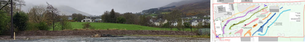
The following image of the revised planning permission site plan show the new Topography of the Parochial Field as submitted in the planning application. The image shows 7 Topography areas between the Topography Contour Lines.
Taking into account the flood levels witnessed, all 7 Topography areas outlined could potentially be flooded. This is extremely concerning as this would imply that the Kids Play Park, Large Substation (Blue Y in site plan) and the new proposed location of the Shed could be impacted with floodwater.
Two of these three items/areas are of particular concern.
- The scenario where the flood waters reach the proposed Kids Play Park is especially concerning as when the water reach this level, it would suggest that the Clonmany Wastewater Treatment Plant would also have been flooded and thus the Kids Play Park could potentially be contaminated with floodwater from the Clonmany Wastewater Treatment Plant. The Clonmany Community Centre was contaminated with flood water from the Clonmany Wastewater Treatment Plant in the 2017 Floods. (As previously detailed in the 'Night of The Big Flood' video.)
- The scenario where the flood waters reach the Large Substation is particularly concerning for obvious hazardous reasons, resultant of the potential catastrophic combination of water and electricity.

Blue Y – Location of the new Large Substation.
The following table show the potential flood areas of concern with regard to the Topographical flood level areas. The Topographical Flood Level Areas are colour coded with regard to the site plan map.