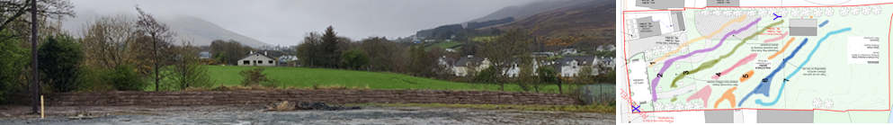
Revised Shed Location
& Flood Maps
Published : 6th Dec 2024
During the planning application process, the location of the proposed shed was revised due to its location in a flood zone. With regard to flooding topography analysis on this website, it is suggested that the revised location of this proposed shed is now in an extended flood zone and the shed is exposed to repeated flooding. The flood zones have been potentially extended due to the development work carried out, the levelling of the Parochial Field in 2017.

Red Y – Approx. location of new Substation
This image includes the original site plan with the proposed shed location (left), the revised site plan with the new location of the shed (right) and an extract from the Flood Zone map from the Donegal County Council ‘Planner’s Report and Recommendation’ report.
The initial proposed location of this shed led to the discovery of the riverside embankment, as this area of the Parochial Field would always be the first area to flood when flood water breached the riverbanks.

Red X and Yellow X - Parochial Field
Red Y and Yellow Y - Shamrock Park, Community Center
The side-by-side comparison of the Donegal County Council (Donegal County Council) Flood Zone Map (left) and the Office of Public Works (OPW) FloodInfo.ie Map (right) is startling.
The discrepancies in the mapped flood zones are astonishing.
Location X - Parochial Field
The Parochial Field is not in a flood zone in the OPW FloodInfo.ie Map. The parochial Field contains a flood zone in the Donegal County Council Flood Map. The Potential Topography Flooding section highlights the reality that this flood zone can be greatly exceeded both by eyewitness accounts and photographic evidence.
Location Y - Shamrock Park, Community Centre
The flood zones depicted for Shamrock Park (Clonmany Shamrocks FC) and the Community Centre are equally startling. The Community Centre is not in a flood zone in the OPW FloodInfo.ie Map, while it is engulfed by floodwater in the Donegal County Council Flood Map. It should also be noted that the Clonmany Wastewater Treatment Plant is not visible in this comparative image as it is engulfed in flood zones in both maps. It is located below the 'Y', at the river (thick red line in the Donegal County Council Map).
The Revised Shed Location needs to be reassessed due to the potential of repeated flooding.
Flood Mapping needs to be reassessed for Clonmany Village immediately.
How can the appropriate planning decisions be made without valid and correct information being available?
As pointed out in the OPW Flood Risk Management Plan section, there is an apparent lack of historical analysis of flooding in Clonmany. Why is this? The reason for this lack of historical analysis needs to be investigated and rectified.
The Office of Public Works needs to reassess the flood risks in the Clonmany area immediately.