Planning Submission / Objection
Published : 25th Nov 2024
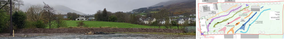
This Planning Submission / Objection was lodged (05/04/2024) by John Bradley to Clonmany Enterprise Development Limited's planning application for the development of the Parochial Field (Festival Funfair Field).
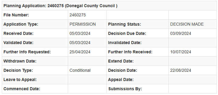
Donegal County Council Planning Department granted planning permission approval on the 22/08/2024
Donegal County Council Planning File Number : 2460275
There have been multiple on-site developments during the planning process and new information has come to light. The Planning Application has been appealed to An Bord Pleanála. This planning application with its multiple issues has been raised with Donegal politicians.
However, I have serious concerns regarding the overall proposed development in the following categories.
1. Environmental
a. Flood Plain
2. Public Health
a. Play Park Location
b. Public Toilet
3. Effects on Residential Amenity
4. Planning Application Inconsistencies
5. Lack of Details Regarding the Management and Operation of the Facilities
6. Vehicular Access
7. Impact on my Mother's Property Value
8. Lack of Public Meetings
1. Environmental
a. Flood Plain Concerns
The Clonmany Community Field also known as the Parochial Field or the Priest's Field has historically been a Flood Plain. It was not unusual for the Flood Waters to be half way up the field and in exceptional circumstances come up close to the old white stone wall at the main road. The old white stone wall was removed to create Diffley Garden.
Growing up, we lived in a prime position to view these floods out our back windows. The old wooden goal posts (long gone) were a good marker/gauge to compare floods over the years. Residents of the village and Clonmany Parish were/are well aware of the flooding of the field and surrounding areas.
In the past, one of these floods caused the closure of the Funfair during the Clonmany Festival which is always held at the start of August.
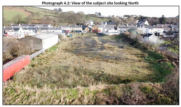
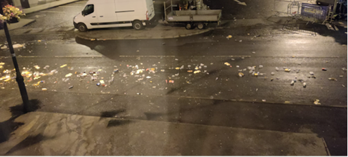
The following photos detail the recent history of the Field with regard to development and potential implications.

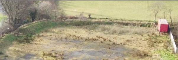
The above photo was taken on the 20th of August 2017, 2 days before the exceptional flooding that struck the region, with Clonmany village being severely impacted.


It is clear from these 2 photos that the embankment at this moment of time only exists approximately half way across the field when compared to the images included in the planning application.
The field historically had 2 mounds of earth a few metres from the river bank. The mounds were between 40-50cm high. The first one started about 1 metre in from the fence at the now, Clonmany Shamrocks football pitch side and extended to approximately a few metres from the middle of the field. There was a gap of approx. 5-6 metres to the start of the next mound which extended to 4-5 metres from the fence of the adjoining field. A drain to the river ran up between the 2 mounds, 4-5 metres from the back of the goals.
As kids we would have had competitions running along these mounds. These mounds would have stopped footballs going into the river when playing football at the old bottom goals.
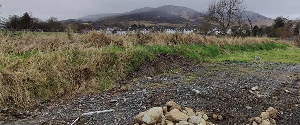

These 2 photos were taken on the 12th of March. An embankment extends across the bottom of the Field at the riverbank.
I went to investigate the bottom of the field, as the location of the proposed shed on the planning drawing immediately caught my attention, as I realized this was one of 2 locations where the flood waters would initially appear in the field historically. The other location being the aforementioned drain to the river from the back of the old wooden goals.
These 2 photos are taken from the Planning Application document and clearly show the extent of the embankment at the bottom of the Field. This embankment potentially removes the previous Flood Plain characteristics of the Field unless the water breaches the embankment.
The Office of Public Works (OPW) website www.floodinfo.ie includes a 'View Flood Maps' section, 'Interactive map to view flood hazard and flood risk information.

The 'View Flood Maps' section comes with a 'Disclaimer and Conditions' section. Visit the website to the latest to get the latest 'Disclaimer and Conditions'.
The following Flood Maps for Clonmany were screenshotted with the following parameters
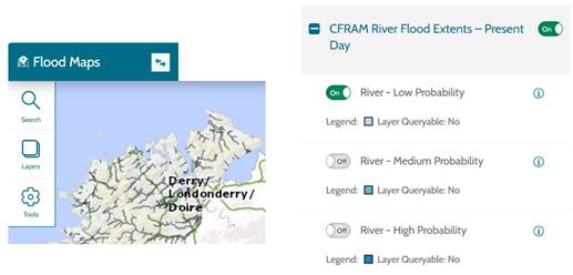

The Parochial Field (marked by the yellow X) in this estimated Flooding Map highlights the effect of the embankment, the embankment potentially removes the previous Flood Plain characteristics of the Parochial Field unless the water breaches the embankment.
While it was initially startling to see these images, I have seen flood waters extended beyond the estimates in the image shown.
When there is a big flood, the 'Big Bridge' can act as a bottleneck, especially if it gets dammed up with debris. Location 'B' in the following map image.

Clonmany Bridge, GADDYDUFF, Clonmany, DONEGAL - Buildings of Ireland

Due to the embankment at the bottom of the Field and the potential bottleneck at the 'Big Bridge', flood waters could be potentially amplified upstream and downstream. Areas of concern could potentially be
1. Downstream at the bottom of the village where multiple elderly residents live. This area was substantially impacted in the flood of 22nd August 2017.
2. Downstream at the Riverside Park estate which also suffered flood damage in the flood of 22nd August 2017. To my knowledge, some or all of these houses are affected by the Defective Blocks issues.
3. Upstream at areas of Shamrock Park (Clonmany Shamrock FC) and the adjacent Clonmany Community Centre
4. Upstream at the Clonmany Wastewater Treatment Plant
Given the extreme rainfall associated with Climate Change in last few years, prolonged extreme rainfall coinciding with high tide and/or with substantial storm surge could have devasting effects for the aforementioned areas.
The effect of the bridge getting dammed up with debris also needs to be considered.
Given the proposed development, surface water runoff also needs to be considered.
The current embankments appear to be formed with soil etc. The Planning Application does not mention if an engineering solution has been used. Without such information, how can the embankments be assessed for long term strength and durability?
There is no Site-Specific Flood Risk Assessment (SSFRA) Report included in the Planning Application. Surely, this is essential given the obvious flooding risks and impact.
The Planning Application submitted does not contain an Environmental Impact Assessment Report (EIAR) with regard to this embankment and the potential concerns listed, especially with its proximity to the Clonmany Wastewater Treatment Plant.
Environmental impact assessment | Environmental Protection Agency (epa.ie)


Bridge/Bottom of Village Region, photos of the exceptional flood in Clonmany 22nd August 2017
These Environmental Concerns need to be thoroughly investigated before any decisions and development can proceed.
2. Public Health
a. Play Park Location
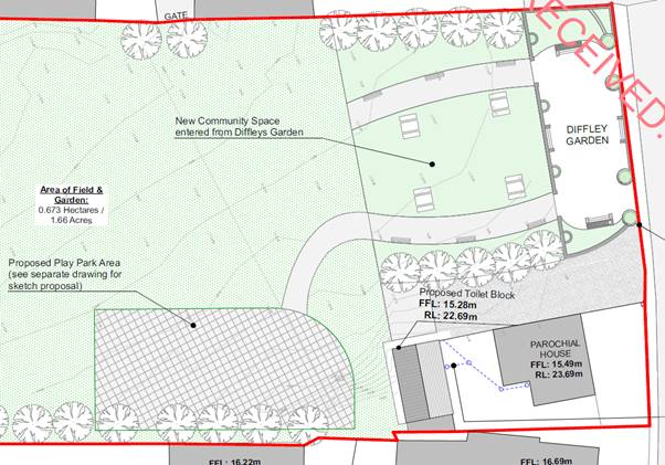
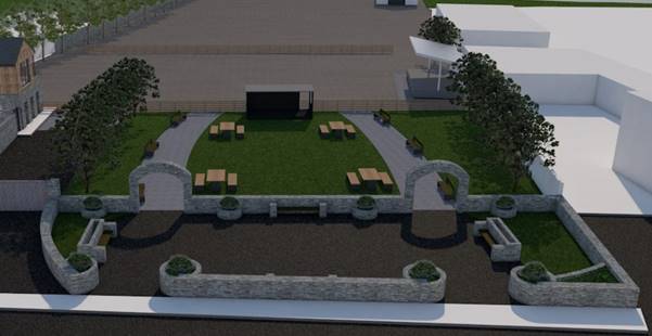
The location of the Play Park is concerning with regard to Public Health. The plan as laid out has Visibility issues, existing Non-Visibility Zone issues and potential newly created Non-Visibility Zone issues due to its location.
Visibility, Non-Visible Zones and Anti-Social Behaviour

Non-Visibile Zone Red X Potential Non-Visible Zone Blue Y
'Line of Sight' lines have been added to the Clonmany Enterprise Development Ltd Planning Application drawing.
These 'Line of Sight' lines highlight the visibility problems with the proposed plan. The Non-Visibility Zones are extremely concerning where Public Toilet Anti-Social Behaviour issues are taken into account.
The proposed trees detailed in the drawing will compound the lack of visibility from the road.
There is extremely limited visibility of the Play Park from the Market Square area. The Yellow Line shows relative visibility from around McFeeley's Pub Door.
The Green Line shows relative visibility from around Mac Tams Bar, the majority of the Play Park area hidden by the trees.
The Light Blue and Dark Blue Lines highlight the Non-Visible Zones behind the Public Toilet Building, a haven for Anit-Social Behaviour and concerning for the safety of kids given the proximity of the Public Toilets and Play Park. Parents will not always be present.

Potential Non-Visible Zone Blue Y
Due to the Play Park location, the fencing around the Play Park in tandem with the play apparatus could introduce further visibility obstructions, potentially creating another Anti-Social Non-Visible Zones, especially in low light conditions.
Visibility in low light conditions is particularly concerning.
Play Park Distance from Main Street

According to Bing Maps Measurement Tool, the proposed Play Park approximate distances from the Main Street are 41m (nearest) and 73-76m (furthest).
As previously stated, the proposed fencing, play apparatus and low light will potentially create Non-Visible Zones and potentially lead to Anti-Social Behaviour.
Due to the distance from the Main Street, a detailed design of play apparatus is key as to not create further Non-Visible Zones within the play area. This is not defined in the proposal.
Other Visibility Hinderances

Visibility from the road is currently impacted from the various signs, fauna and street lights.
Embankment - Play Park Fence

There is a lack of details with regard to Play Park fence and the embankment to the adjoining property. Will there be free access to this embankment which could cause erosion and damage to the embankment and create another Non-Visible Zone to act as another Anti-Social Behaviour area?
Will the pole and its wires have to be moved, given that children could possibly be kicking footballs in this area?
Play Park located metres from a Home Heating Oil Tank

The closest area of my mother's backyard to the Play Park Area contains a Home Heating Oil Tank. Located at XX in the above plan image. According to Bing Maps Distance Measuring Tool, this Oil tank is metres from the proposed Play Park.
This is not an ideal scenario.
b. Shed Location

The location of this proposed shed is the location of where the flood waters would initially appear in the field prior before the existence of the embankment.
In the 70s, 80s and 90s, village pre-teen and teenage lads fished the Clonmany River extensively. We had extensive knowledge of the flooding patterns of this river.
This type of flooding would happen on a regular basis, flooding in and around the bottom goal posts. This was most visible from the upstairs back bedrooms of our house.
As previously stated, the current embankments at the bottom of the field appear to be formed with soil etc. The Planning Application does not mention if an engineering solution has been used. Without such information, how can the embankments be accessed for long term strength and durability?
The location of the shed adds another Non-Visible Zone with potential for Anti-Social Behaviour at the river side of the building.
c. Public Toilets
Over the last couple of decades in Ireland, Public Toilets have been disappearing from the landscape of our villages, towns and cities.
Although not publicised, Councils
and Corporations appear reluctant to build them due to Anti-Social Behaviour
and Operating Costs.

In a recent article in the Irish Independent regarding a Campaign for more public toilets in Dublin, it is obvious that there is a huge reluctance by the Dublin Corporation to provide such facilities. The quote from former Dublin Lord Mayor and Councillor Hazel Chu is very telling.

It would appear that Dublin Corporation are reluctant to provide Public Toilets in Dublin City Centre with its high footfall and high traffic.
Clonmany Village has extremely low footfall and low traffic, with the exception of 1 week per year. Festival week is currently satisfied with the rental of portaloo's and toilets in the Market House directly across the road from my mother's house in the Market Square. The Market House is open throughout the year.
Online Research : Public
Toilets
As part of the Planning Application journey, I carried out online research (Google Search) into Anti-Social Behaviour into Public Toilets. It is not a journey that I would recommend. The non-exhaustive, distressing results include
- Paedophiles
- Sexual Predators
- Indecent Exposure
- Hidden Cameras
- Child Pornography
- Drug Dealing
- Drug Taking Facilities
- Prostitution
- General & Cocaine Fuelled Violence
- Vandalism
Searching on Google with any of these terms preceded with 'Public Toilet' will provide distressing results.
Sample Search : Public Toilets Vandalism
Clonmany Enterprise Development Ltd were made aware of these findings and these findings can be made available to the local community if so requested, with a Health and Wellbeing warning attached.
Distance from my Elderly Mother's Kitchen

Bing Maps Distance Measuring Tool shows that these proposed Public Toilets would be 14m from my mother's kitchen, a short distance from the proposed Play Park with a Non-Visible Zone in between.
This Non-Visible Zone is of major concern from an Anti-Social Behaviour point of view. My mother has been subjected to Anti-Social Behaviour while going out to put clothes on her clothes line in the past. She was both horrified and upset.
Public Toilets Vandalism

The proposed Public Toilets do not appear to take into account WC features to try to combat Vandalism.
- Back-to-wall toilets
- Vandal-resistant sensor taps
- Concealed trap urinals
- Anti-vandal recessed hand wash and dryer units
Issues not addressed in the Planning application include :
Will a facilities Manager be appointed?
How often will the toilets be cleaned?
What is the opening and closing times of the toilet?
Will the toilets contain baby changing facilities?

Public Toilets Distance from Main Street

The proposed Public Toilets are located at a minimum 31 metres from the nearest visible point on the main road.
In reality, road traffic from the bottom of the village will only have visible access to the toilets due to the fact they are facing in the direction of the toilets. See previous discussion on Visibility Issues regarding the Play Park, the majority of which also apply in this scenario.
Distances measured using Bing Maps Distance Measuring Tool.
The proposed Public Toilet's location is not in a busy location, with multiple visibility issues and should be relocated if deemed necessary for such a small village.
The proposed solution is not ideal for Less Abled users and there are no defined access route details for Less Abled users from the Main Street.
Public Toilet Drainage & General Drainage
The Planning Application has no details for new drainage apart from reference re connection to Parochial House. No further details offered. Also notes obscured by the title block.

Assuming that these toilets would be operational during the Clonmany Festival where some nightly crowds can be well in excess of 10,000 people, would the current Parochial House drainage and current village drainage system cope over the 8-day event?
Moreso at the time of the Clonmany Festival, the potential additional intensity of sewage could lead to environmental concerns and attract rodents.
Blocked drains and the ensuing stench are a major concern for my mother. This is a particular concern as my research showed that 'Deliberate blocking of toilets' is an issue with Public Toilets.

There are no land drainage references at all for new buildings and play area and green areas in the drawings.
I suggest that these aforementioned issues potentially provide a threat to Public Health and Safety for both the young and the old.
3. Effects on Residential Amenity
Imposing New Structure
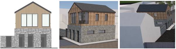
The proposed Meeting Rooms on top of the Public Toilets will tower over my mother's single storey kitchen building. It will block out the afternoon and evening daylight/sunlight. The footprint of the proposed building appears to be similar to the existing shed structure.

Photo from my mother's kitchen sink window.

Photo from my mother's kitchen : side window.
The proposed building is far too close to the boundary. It is overpowering, overshadowing and overbearing. It will lead to a loss of light and over shadowing. The aspect of the kitchen with respect to the proposed building needs to be taken into account.
A Shadow Analysis is integral to this planning application.
All of these issues will have a significant detrimental
impact on my mother's residential amenity, is contrary to the zoning objective
for the area as set out in the County Development Plan, and would be contrary
to the proper planning and sustainable development of the area.
Maintenance of the proposed building
The larch on the building will need treating. With this being so close to the boundary, this will make this treating very difficult without encroaching onto third party lands.
Noise Pollution

This image shows my elderly mother's --removed-- outdoor relaxation area. The proposed Play Park would begin at the pole at the opposite side of the wall to the Play Park.

Having lived in the Market Square prior to Clonmany Festival's inception, she understands and deals with certain levels of noise pollution. For 8 days of the Clonmany Festival, at certain times of the day, her abode is engulfed in noise. A minimum of 10 concerts out the front of the house, a minimum of 8 days of funfair out the back and side of the house and 8 early morning sessions of the dreaded street cleaners.
The noise from the street cleaning operation is by far the loudest of the 3. I took this photo on the 14th Aug 2023 at 04:53am, after the closing night of the festival. As expected, it woke both me and my mother, who got up and made herself a cup of tea.
My mother and my father were highly active in the formative years of the Clonmany Festival as outlined independently to me by the joint co-founders of the Clonmany Festival. The planning application proposers, Clonmany Enterprise Development Ltd are now the current guardians of the Clonmany Festival.
My mother was widowed at the age of 40 with 6 children in a devastating and sudden fashion. My mother is in her 80s and currently very active, takes delight in sitting out in her backyard.
Extending the noise pollution to 365 days a year would be unthinkable.

The noisy Play Park Area would be located in a residential area, metres from my elderly mother's back yard, 15 metres from my mother's kitchen according to Bing Maps Distance Measuring Tool.
A Noise Analysis is integral to this planning application.
The combined effects of the two-storey structure with associated facilities, impacting light and aspect amongst other characteristics and the Play Park would be detrimental to my mother's health and wellbeing and quality of life in the home she has occupied for almost 52 years.
Light Pollution
A Light Pollution Analysis is integral to this planning application given the type of developments and the facilities involved. The submitted plan lacks the necessary details such as
- a description of the proposed hours of operation, light spillage, light levels and column heights
- a layout plan of the proposed development site showing beam orientation
- details of the proposed equipment design
- details of the expected impact on neighbouring properties and roads
- a statement of any proposed measures to mitigate or compensate for the possible impacts of the proposed development
- for example, through the planting of trees, hedges or shrubs
Consequences of Intensification of Use
Due to the building of the proposed Public Toilets, this could lead to the Intensification of Use of the field for additional events in addition to the Clonmany Festival.
This consequentially would lead to and impose on my mother and the local residents additional Noise Pollution, Light Pollution, General Disruption and Hardship.
This needs to be considered and possibly addressed in the planning decision.
4. Lack of Details Regarding the Management and Operation of the Facilities
The planning application does not include any details regarding the management of the Public Toilets and the Play Park Area. These include operating hours, day to day servicing, cleaning and supervision. The lack of these details makes it difficult to fully assess the impacts of the proposal on both my mother's property and surrounding properties.
Access Time To Play Park
The Planning Application does not specify any opening and closing times. There is a precedence for this.
Precedence
21-50015
Playground in Falcarragh.
This retention planning application was granted by DCC but taken to Bord Pleanála and approved but with restricted operating hours of:
Summer April 1st to Sept 30th 09.00-19.00
Winter October 1st to March 31st 09.00 - 16.00
Co Dev Plan - Clauses CCG-P-1 and CCG-O-5
4. Planning Application Inconsistencies
There are inconsistencies between the plans and images in the planning application.
The play area noted on the plan does not appear in the 3D images and a rectangular darkly finished building shown in the 3D images does not appear on the site layouts. I would have thought these would be requirements for validation as I am under the impression that all proposals have to be coordinated for validation.
The previous visibility analysis using sightlines is partially redundant as the visibility from the street to the Play Park area is further compromised by the arches in the 3D drawings and the rectangular darkly finished building.
3D images from various points on the road at car and pedestrian level would be very helpful in determining areas of concern for the Public Toilets, Play Park Area and Non-Visible Zones.

There are also inconsistencies between the plans submitted and my mother's current attached kitchen building in the planning application. The blue X shows the attached building prior to 2016. The red Y shows the existing kitchen building that was completed in 2016, source Bing Maps.
5. Vehicular Access
It is not clear as to the extent of vehicular access or any associated car parking.
The dark grey area directly to the west of the parochial house, creates the impression of being tarmac with a narrow footpath to two sides of the Public Toilet block. If this is the access point for the annual Clonmany Festival Funfair, I would question the width of the clear access available for the large Funfair vehicles and trailers containing amusement rides without clashing with the play park area.
No details are supplied for Less Abled users of the Proposed Toilet Block.

6. Lack of Public Meetings
For a project of this size in the heart of the community, there has been no public meetings on this matter.

I would propose there should be a fully fledged discussion within the community to bring forward a community led plan, given that it is called the 'Clonmany Community Field' Project. There are community facilities, that are fully accessible, where such a meeting could be held, and due notice given to allow community members to plan to attend.
7. Impact on my Mother's Property Value
Having regard to the number of issues outlined above and
1 the proximity of the facility which includes public toilets, directly adjacent to my mother's primary private amenity space impacting light and aspect will result in the devaluation of my mother's property.
2 the proximity of the Play Park and the associated noise pollution, directly adjacent to my mother's primary private amenity space, I consider that the proposed development will result in the devaluation of my mother's property.
In conclusion I suggest that the Plan submitted by the Clonmany Enterprise Development Ltd needs to reassessed due to the concerns listed and put to the community once the environmental concerns are investigated and addressed.
I would appreciate if my observations could be taken into account in the consideration of this application.
Yours Sincerely,
John Bradley